Overview


|
Field Book |
|
|---|---|
|
New Fieldbook |
Creates an empty Survey Fieldbook. The new Fieldbook is made active by default. |
|
Delete Fieldbook |
Deletes the selected fieldbook. |


|
Data |
|
|---|---|
|
Load Data |
Specifies the data file type to load and the Fieldbook to use within Survey. |
|
Export |
Exports to one of Bentley’s native surface formats or to LandXML. |


|
Edit |
|
|---|---|
|
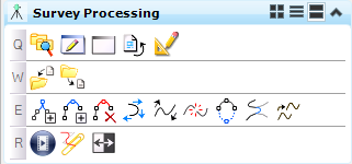
Append Point in Linear Feature |
Appends a civil point to an existing linear feature. |
|
Insert Point in Linear Feature |
Inserts a civil point in an existing linear feature. |
|
Remove Point in Linear Feature |
Removes a civil point from a linear feature. |
|
Move Point Along Linear Feature |
Moves a Point Feature along an existing Linear Feature. |
|
Transpose Linear Feature |
Reverses all data within the selected horizontal alignment. The first element becomes the last element, and so forth. |
|
Break Linear Feature |
Breaks one linear feature into two distinct linear features. |
|
Close Linear Feature |
Connects the first point of the linear feature with the last point. |
|
Join Linear Features |
Joins two linear features to form a single new linear feature. |
|
Move Linear Feature |
Moves a Point Feature along an existing Linear Feature. |


